
It’s done! Sixty one days and 2125km after setting out from Qacha’s Nek in Lesotho we paddled through the thick early-morning fog that envelops the coast near Alexander Bay to reach our final destination: the mouth of the mighty !Gariep River.

On the beach at Alexander Bay just after pulling the kayaks up and out of the water for the last time at the mouth of the !Gariep River.
Here we were met by Sam’s dad Peter and girlfriend Kate, who had negotiated the tricky final stretch of deep sand to welcome us at the mouth with champagne. And all of a sudden that was that…the river life we’d grown so accustomed to over the previous months had come to an end. It was a little hard to comprehend right then and there, but the champagne put paid to any deeper philosophical musings.

Hills and koppies of the coastal forelands stretching to the higher mountains of the Richtersveld in the far distance.
The rocks of the Richtersveld are some of the oldest on planet Earth and, because of the almost total lack of vegetation, the fascinating geology of this area is on full display.
Interestingly, different rates of erosion of softer and harder rocks has resulted in a stepped relief, with harder rock layers forming natural weirs which have trapped boulders washed downstream over time. This has created many of the rapids for which this stretch is famous. As with most of our trip we found the rapids in a forgiving mood and negotiated the Sjambok, Gamkab, Rollercoaster, Rocky Horror, etc., etc. rapids without incident. We did get out of our boats to have a peek at Sjambok, but it was quickly decided that the couple of hundred metre walk to inspect the meat of the thing was too much effort. We were obviously getting a little too flippant because, closer to the confluence with the Fish River, an unnamed and rather benign rocky rapid caught Sam off guard, forcing his boat between two large boulders and into some churning water on the other side, with him taking an unceremonious swim. Ian was swift to capitalise on his misfortune by pointing out the old paddlers’ adage of a round of drinks on the last swimmer. His initiative came back to haunt him at a slightly more note-worthy rapid the following day, as he was bundled out of his boat along with some electronics – he was clearly not expecting to take a swim. Fortunately he was met downstream by very sympathetic teammates with suggestions of their preferred beers. Now with beers on the line, the last few rapids assumed critical importance, with usually co-operative team members employing all sorts of smoke-and-mirror methods to throw each other off the scent of the easiest line through. Sam and James proved equal to the task though, and eagerly await their bounty.

The mountains and scenery in the Richtersveld were magnificent.
We spent the better part of a day paddling past Aussenkehr, the largest farm in the Southern Hemisphere, fronting some 40km of the !Gariep River and containing what is effectively one of the biggest towns in the area, housing a community of thousands of permanent and seasonal workers and the infrastructure required to support them.
Aussenkehr is also the location of what must be the only Spar located on a farm, at which we were happily able to stock up with a few luxuries for the last few days after a relatively lean restocking attempt in Noordoewer. Pickings were still a bit slim for this final leg though, forestalling any early celebration and forcing a little culinary inventiveness: Ina Paarman probably did not envisage her pesto as an accompaniment to bully beef, but we found the result delicious.
On the whole we’ve eaten rather well though, which I suppose is necessary given the energy intensive lifestyle we’ve been leading. An unintended consequence is that our food bags have been the source of much attention from our primate cousins, and on two occasions we suffered losses from baboons and vervets respectively. In the one instance, however, Ian had thankfully put his larger brain to good use and packed in layers, with the Eet-Sum-Mor’s surviving the raid at the expense of the less important bread and tomatoes.
The Richtersveld/Ais-Ais Transfrontier Park, which flanked us both left and right for much of this section, is somewhat unusual with respect to its governance structure. It’s both a peace park – a joint agreement between the governments of RSA and Namibia to conserve the land bordering the !Gariep River – as well as a community-run park. This means the inhabitants of four local Nama communities have grazing rights and (depending on which source you go with) rights to mine within the park boundaries. In return for leasing the land to SANParks these communities also receive other benefits such as access to transport and educational scholarships. It seems like a progressive arrangement, although we were surprised (despite assurances to the contrary by a SANParks staffer at Sendelingsdrif) at the inclusion of mining as a permissible activity, which seemed to be ongoing within the park.

We were somewhat puzzled and distressed to see what looked like active diamond mining taking place within the borders of the Richtersveld National Park, as depicted in this photograph.
Despite the prevailing aridity, we were treated to some intriguing game viewing en route to the coast. Late one night we were awoken for the second time on the trip by a strange thrashing noise emanating from the river. Our torchlights revealed the heads of dozens of massive barbel, all bunched together with their mouths gaping open at the water’s surface. We’d previously seen this phenomenon at our camp below Kum-Kum Falls and had debated whether it might be some form of migration, perhaps to deeper water. However, the aggressive splashing and herding formation in the direction of the shallows suggested that it was some kind of pack hunting strategy. Indeed, closer inspection revealed numerous smaller fish hiding in the shallowest water between rocks and cobbles. We think that the barbel scare smaller fish into the shallows and that many of these fish try and escape by leaping out of the water, landing in the awaiting barbel mouths. If anyone has more insight on this, we would be pleased to hear from you.
Closer to the coast we also came upon ever greater numbers of gemsbok on the Namibian side of the river, coming down from the sparsely vegetated dunes for a drink. On one occasion we had the privilege of paddling right up to a good sized herd which were patiently and gracefully swimming – with just their heads and horns exposed – across a channel in the river from an island on which they had been grazing. A truly magnificent sight!

Gemsbok running wild along the riverbanks on the Namibian side. Seeing these majestic creatures made us feel like we had stepped back in time to an era before much of the wildlife had been hunted out in Southern Africa.
The river then leaves the mountainous terrain of the Richtersveld around Sendelingsdrif and enters the coastal forelands, flanked by dunes and vast expanses of desert sands.

Desert sands became a common occurrence in the valleys and on the plains and mountain slopes as we neared the cold Atlantic Ocean coastline.
Just before Sendelingsdrif we passed signs of a huge mega-weir construction project – part of an ambitious inter-governmental scheme to bring a reliable source of water to the people, and a more natural flow regime to the mouth of the river. As ever, the search for a balance between human and ecological needs goes on.
Below Sendelingsdrif one finds the curiously (we thought humorously) named settlements of Brandkaros (Burning Blanket) and Grootderm (Large Intestine). Diamond mining ramps up appreciably in these parts, and huge dumps of stone, sand and mining debris are visible not far from the river banks.
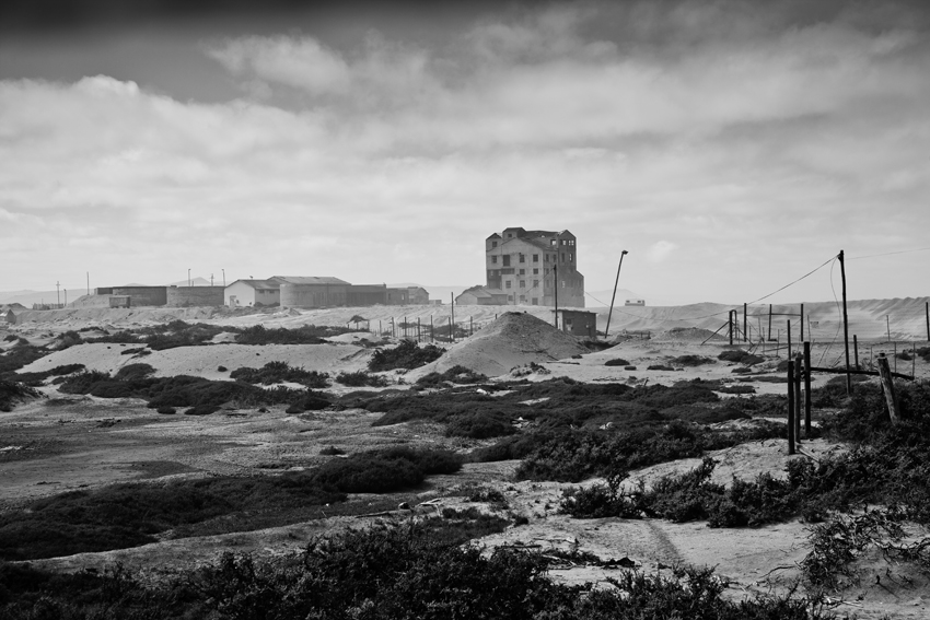
Abandoned diamond mining buildings just behind the coastal dunes near the !Gariep River mouth.
We were told that the entire section of river from Sendelingsdrif was a no-go zone, but we didn’t feel the need to travel incognito until the final few kilometres.

A rather ominously worded sign in the diamond mining area.
The proposed covert SENQU2SEA mission amounted to a laughable attempt to pass underneath the Alexander Bay-Oranjemund bridge undetected. After fumbling around in camp for an hour with our headtorches, we set off at 05h30 into a fog that obscured what little starlight was supposed to guide us. After 50 metres we hit our first sandbar. We spent the next hour waffling and zig-zagging the 2km to the utterly deserted bridge. Here we nearly came to grief on a line of steel poles and cement bollards: the remnants of an earlier bridge washed away by floods, resulting in whispered shouts of caution and heaving paddle strokes from Sam leading the way. We joked that we couldn’t possibly be mistaken for diamond smugglers as we were clearly completely inept at stealth. We then drifted slowly downstream waiting for first light, shivering in a light headwind and disturbing a few snoozing groups of pelicans.

Pelicans on the !Gariep estuary.
The last few kilometres were a lovely paddle through lifting mist and fog in the soft dawn light, with the smell and roar of the Atlantic growing slowly stronger.

Final stretch to the coast in the mist.
We must have arrived at the changing tide, because we were able to paddle right up to the river mouth, being washed ashore for the final time by small wavelets. A few local fishermen were already at their business nearby. As we hauled our boats ashore it didn’t feel as if anything was out of the ordinary.
We’re returning home with some pretty weird calluses, many good memories, and even more data.
In fact, it’s a veritable mountain of data, which will take some weeks to work through. We’ve painstakingly collected 61 diatom and water samples, one approximately every 40km for the entire length of the river; 53 isotope samples taken in tributaries of, and within the Senqu and !Gariep Rivers themselves; well over 1200 GPS locations of interest, including around 500 water abstraction points and 500 fish eagle, goliath heron and giant kingfisher sightings. (Never before has a statistician collected so much raw data – Ian is a rare breed indeed!). We also recorded and photographed the location of all significant bird nesting colonies along the length of the river, as well as mining activity. Hundreds of points record the location of fishing activity, starting from the town of Aliwal North. James studiously recorded bird species observed on a daily basis, amounting to a continuous record of species presence along the entire length of the river. He also hauled his camera out more than 1060 times (that’s approximately once every 2km) to document riverine vegetation, and scrambled up 60 koppies to take a series of quite outstanding high resolution landscape panoramas. All this data amounts to a thorough and carefully captured snapshot of most of the Senqu River and the entire !Gariep River system, and something we’re quite proud of. We hope it’ll be of much use as a baseline dataset and as a resource to current and future researchers of the Senqu and !Gariep Rivers.

Juvenile Yellowfish were inquisitive fish, often swimming around us when we went for a dip in the river to cool off.
We’d like to take this opportunity to thank you for joining us along our journey, for all your encouragement, comments and corrections. We’ve thoroughly enjoyed your company along the way! With respect to the blog, we’d like to say a special thank you to Caitlin von Witt (aka Squirmy Worm, as Ian and Sam learnt early on) for being such an outstanding PR liaison person. She took text and photos from three angular and abrasive individuals, ran it through several hundred class 5 rapids, and delivered a rounded and smoothly polished product to our adoring fans (i.e. parents). We’re also very grateful to Yolandi Els, co-ordinator of the Arid Lands Node of the South African Environmental Observation Network (http://www.saeon.ac.za) and Prof. Timm Hoffman of the Plant Conservation Unit (http://www.pcu.uct.ac.za) at UCT for providing some funding and logistical support for the expedition. Anyone interested in accessing the data should please get in touch with either Yolandi or Timm, as SAEON and the PCU will be the primary repositories for the data.
There are many more thank you’s to be said to people who helped us before we left, and all along the way. We’ve decided against a long list of names; you (and we!) know who you are. Instead, we’d simply like to say a sincere THANK YOU! to all of you. You enriched our journey, your generosity touched us deeply, you showed us the way.
A last parting thought: what we did wasn’t actually that remarkable, what was remarkable was that we DID it!
Southern Africa is full of adventurous potential, and friendly people, should you need some help with directions. We live in a corner of the world where you can get lost, and find yourself, just as easily. What’s more, it doesn’t need to involve a huge financial outlay, or a massive carbon footprint.

Paddling through the Richtersveld/Ais-Ais Transfrontier Park. A truly beautiful part of Southern Africa and well worth a visit.
So next time you’re in need of some rejuvenation, go beach camping up the West Coast, go walking in the Cape mountains, or go cycling on some quiet farm roads. There are rich memories out there to be made, and the stars will light your way (except in Alexander Bay)…

Covert paddling under the cover of darkness and early morning mist to make it past the Alexander Bay borderpost in order to avoid being denied entry into the diamond mining area and our final destination, the sea.
PS. Watch this space for more exclusive SENQU2SEA behind-the-scenes video footage (yet to emerge from the editing room).
